
; it depicts the gargantuan Victoria regia water lily, which Schomburgk found in the upper reaches of the river Berbice, and brought back to England where a special house for it was built at Chatsworth.") View larger
View larger
Twelve Views in the Interior of Guiana: from drawings executed by Mr. Charles Bentley, after sketches taken during the expedition carried on in the years 1835 to 1839, under the direction of the Royal Geographical Society of London, and aided by Her Majesty’s Government. With descriptive letter-press, by Robert H. Schomburgk, Esq. Accompanied by Illustrations on wood
- Subjects
- Archaeology, Americas
- Guyana - Description and travel
- Authors/Creators
- Schomburgk, Robert Hermann, Sir, 1804-1865
- Artists/Illustrators
- Bentley, Charles, 1805/1806-1854
- Morrison, John, active 1837-1839
- Printers/Publishers
- Ackermann, Rudolph, 1799-1859
- Whitehead and Co., active 1838?-1872?
- Other names
- Devonshire, William Spencer Cavendish, 6th Duke of, 1790-1858
Schomburgk, Robert Hermann, Sir
Freiburg (Saxony) 1804 – 1865 Schöneberg
Twelve Views in the Interior of Guiana: from drawings executed by Mr. Charles Bentley, after sketches taken during the expedition carried on in the years 1835 to 1839, under the direction of the Royal Geographical Society of London, and aided by Her Majesty’s Government. With descriptive letter-press, by Robert H. Schomburgk, Esq. Accompanied by Illustrations on wood.
London, Ackermann & Co. (Whitehead and Co. Printers), 1841
folio (535 × 365 mm), (22) ff. letterpress, signed a1 (title-page) b1 (drop-title, Preface), π1 (drop-title, List of Subscribers, dated on verso 1 December 1840) A–K2 (–K2, cancelled) and paginated (6) 1–38, with ten wood-engraved vignettes printed with the text (on pp.6, 10, 16, 25, 26, 28, 31, 35, 36, 37); plus hand-coloured title/frontispiece (with Ackermann’s imprint, dated 3 August 1840), dedication leaf (to William Spencer Cavendish, Duke of Devonshire, his insignia printed in gold), a ‘Map of Guyana’ (outlined in red and blue), and twelve hand-coloured lithograph views.
Loosening in binding, occasional spotting, otherwise a fine copy with all the plates in exceptionally fresh state.
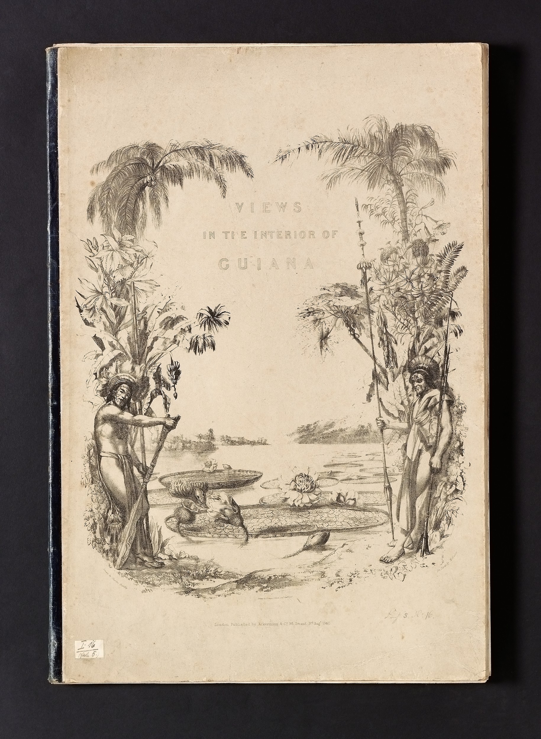
bound in the publishers’ leather-backed grey boards, lithograph on upper cover (from the same stone used for the title-page, but here printed in black only).
A fine, coloured copy in the original printed boards of Schomburgk’s account of his exploration of the Upper Guiana River basin, conducted in three expeditions in 1835–1839 under the auspices of the Royal Geographical Society. It is the first book with coloured plates depicting the topography of the British colony and is regularly exhibited.1

Schomburgk returned to England in September 1839 and within months had conceived his Twelve views.2 The book was published by subscription, with advertisements placed both in London and in Guiana. The list of subscribers printed in the volume runs to 360 names, including 209 colonial officers and plantation proprietors residing in the colony – an astonishing 5% of the local white population.3 The work was issued plain (at £2 12s 6d) and on large paper, coloured (4 guineas). Abbey’s copy was also in ‘original stiff wrappers: front wrapper lithographed, as the lithographed title’, but was uncoloured.
The twelve views of British Guiana were drawn by John Morrison, a draughtsman living in the colony who accompanied Schomburgk on his third expedition into the interior in 1837–1839.4 Schomburgk arranged for Morrison’s drawings to be embellished by Charles Bentley (d. 1854), an illustrator of travel books for Ackermann and landscape watercolourist, and transferred to lithographic stones by George Barnard (7 plates), Maxim and Paul Gauci (3), and Coke Smyth (2). In the ‘Preface’, the author credits the draughtsman Charles Blunt and the blockcutter G.P. Nicholls for the woodcuts illustrating the letterpress.

The frontispiece, a ‘gift’ to subscribers beyond the promises of the prospectus, depicts the gargantuan Victoria regia water lily, which Schomburgk observed in the upper reaches of the river Berbice. Though seen by other explorers, it was Schomburgk who managed to bring a specimen to England, where a special house for it was built at Chatsworth. Through Schomburgk’s frontispiece, the flower became established as a symbol of Guiana, imperial splendour, and of tropical fertility as well.
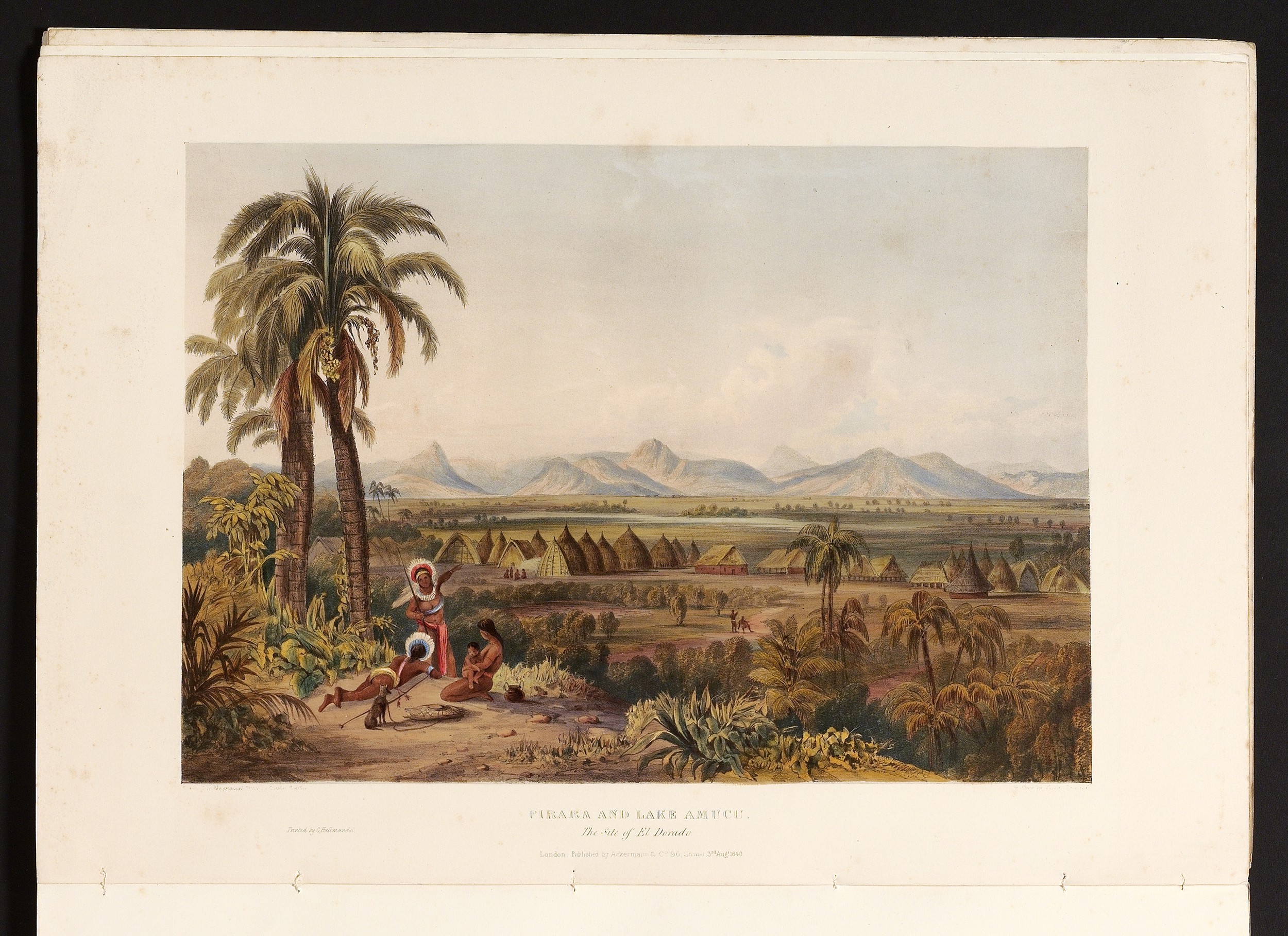
The map (388 × 272 mm) was prepared by the geographer John Arrowsmith on the basis of Schomburgk’s survey reports. The place-names underlined in colour on the map are the sites illustrated in the book and each view is captioned with its precise geographic coordinates.
references Joseph Sabin, Bibliotheca Americana: A dictionary of books relating to America, from its discovery to the present time (New York 1868–1936), no. 77796; John Roland Abbey, Travel in aquatint and lithography, 1770–1860: a bibliographical catalogue from the library of J.R. Abbey (London 1956–1957), no. 720; Ronald Vere Tooley, English books with coloured plates, 1790–1860 (reprint London 1987), no. 447; Rubens Borba de Moraes, Bibliographia brasiliana: rare books about Brazil published from 1504 to 1900 and works by Brazilian authors of the colonial period (revised edition, Los Angeles & Rio de Janeiro 1983), p.782
1. Cf. Europeans in Latin America, Humboldt to Hudson, catalogue of an exhibition held in the Bodleian Library, December 1980–April 1981, edited by R.A. McNeil and M.D. Deas (Oxford 1980), p.36 no. 82; América exótica: panorámicas, tipos y costumbres del siglo xix: obras sobre papel: colecciones de la Banca Central, Colombia, Ecuador, México, Perú y Venezuela, catalogue of an exhibition held 2004–2005 at the Biblioteca Luis Angel Arango, in Bogotá, Colombia, edited by Patricia Londoño Vega (Bogotá 2004), pp.56, 87 no. 64.
2. See the announcement ‘a forthcoming work of promise’ in The Athenaeum, no. 634, 21 December 1839, p.965.
3. D. Graham Burnett, Masters of all they surveyed: exploration, geography, and a British El Dorado (Chicago 2000), p.125.
4. Morrison is described in Schomburgk’s unpublished Report as a native of Glasgow; see The Guiana travels of Robert Schomburgk, 1835–1844. Volume i, Explorations on behalf of the Royal Geographical Society 1835–1839, edited by Peter Rivière (London 2006), p.236. He was ridiculed by William Hilhouse as an ‘execrable dauber’ (Burnett, op. cit., p.134).