
, etched by Laurens Scherm (516 × 613 mm, platemark)")
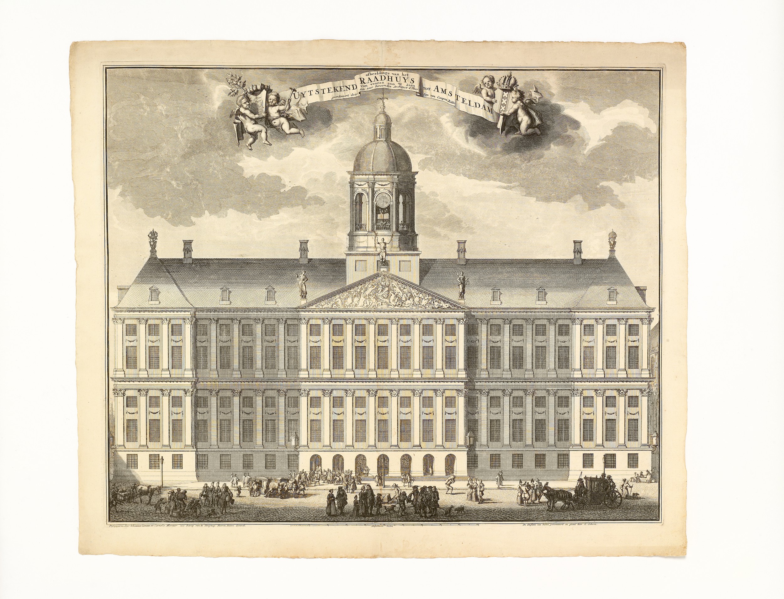
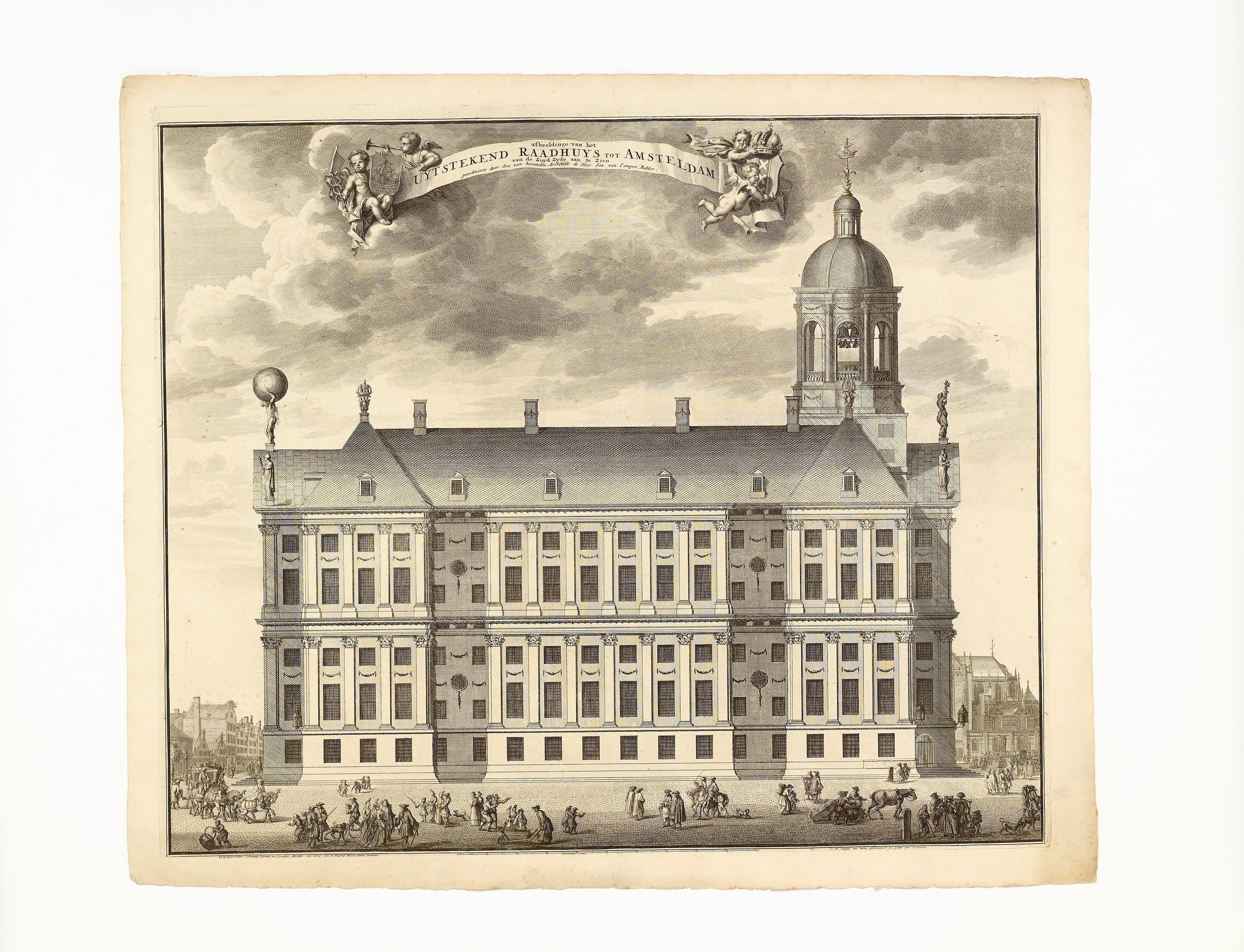
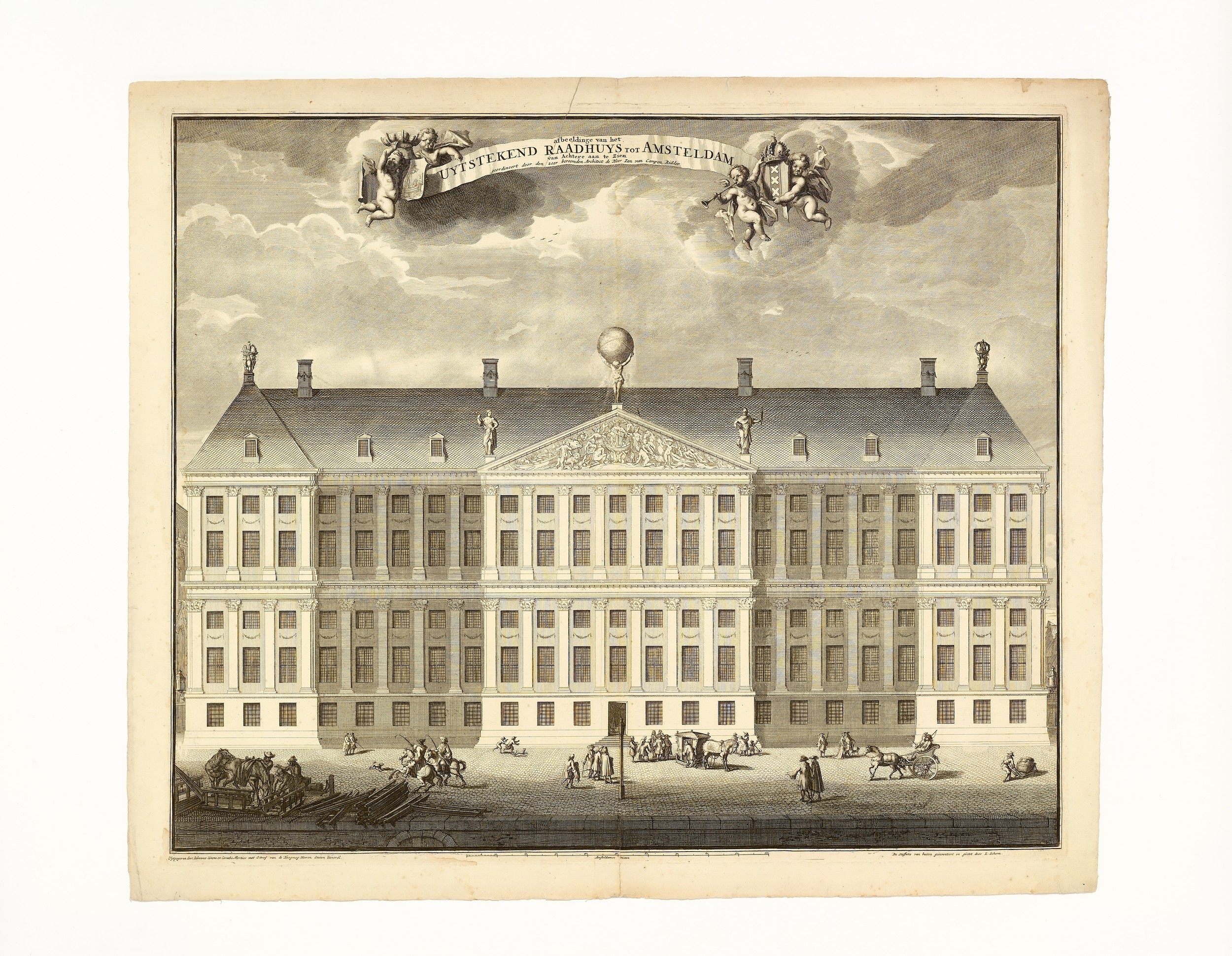
Afbeeldinge van het Uytstrekend Raadhuys tot Amsteldam… geordineert door den zeer beromden Architect de Heer Ian van Campen Ridder
- Subjects
- Architecture, Dutch & Flemish - Campen (Jacob van), 1595-1657
- Architecture, Dutch & Flemish - Early works to 1800
- Architecture, Dutch & Flemish - Stalpaert (Daniël), 1615-1676
- Prints - Artists, Dutch & Flemish - Scherm (Lorenz), active 1690-1700
- Authors/Creators
- Campen, Jacob van, 1595-1657
- Artists/Illustrators
- Campen, Jacob van, 1595-1657
- Scherm, Lorenz, active 1690-1700
- Stalpaert, Daniël, 1615-1676
- Printers/Publishers
- Covens, Johannes, 1697-1774
- Mortier, Cornelis, 1699-1783
- Owners
- Leonhardt, Johannes Hermanus Henricus, 1833-1904
- Leonhardt-Pilz von Wernhof, Gertrude Emilie Anna Mathilde, 20th century
Campen, Jacob van
Haarlem 1595 – 1657 Amerfoort
Afbeeldinge van het Uytstrekend Raadhuys tot Amsteldam… geordineert door den zeer beromden Architect de Heer Ian van Campen Ridder.
Amsterdam, Johannes Covens & Cornelis Mortier, [undated; circa 1725]
suite of five prints (matrices 516 × 613 mm, sheets 566 × 667 mm), complete, in second (of two) states, lettered:
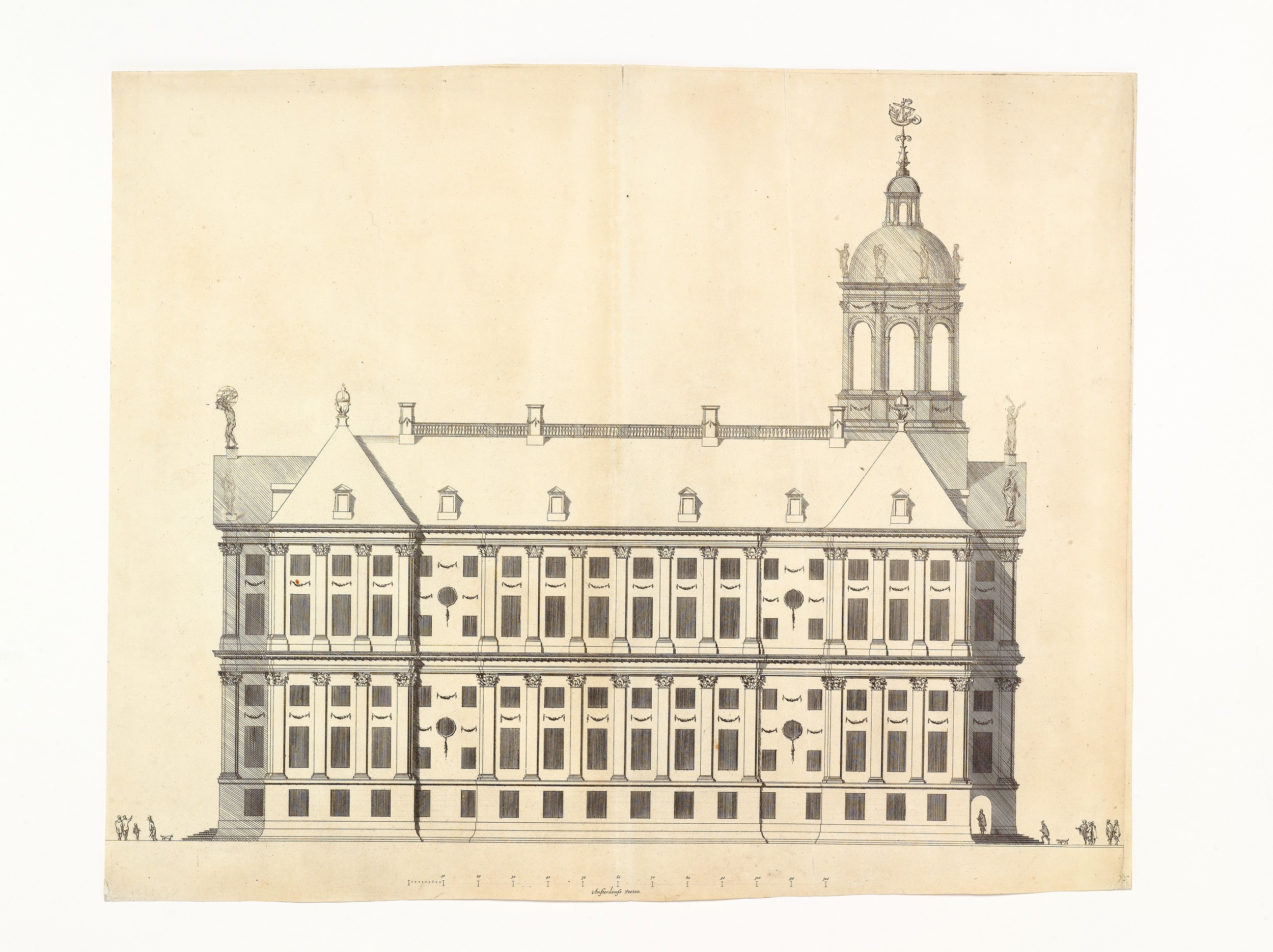
(i) titled at top centre Afbeeldinge van het Uytstrekend Raadhuys tot Amsteldam van vooren aan te Zien geordineert door den zeer beroemden Architect d’Heer Ian van Campen, Ridder; in lower margin Uytgegeven door Johannes Covens en Cornelis Mortier met Octroy van de Hoogmog; Heeren Staten General. | [scale expressed in ‘Amsteldamse Voeten’] | De Stoffatie van buiten geinventeert en geetst door L: Scherm
(ii) titled at top centre Afbeeldinge van het Uytstrekend Raadhuys tot Amsteldam van Actere aan te Zien geordineert door den zeer beroemden Architect d’Heer Ian van Campen, Ridder; in lower margin Uytgegeven door Johannes Covens en Cornelis Mortier met Octroy van de Hoogmog; Heeren Staten General. | [scale expressed in ‘Amsteldamse Voeten’] | De Stoffatie van buiten geinventeert en geetst door L: Scherm
(iii) titled at top centre Afbeeldinge van het Uytstrekend Raadhuys tot Amsteldam van de Zuyd Zyde aan te Zien geordineert door den zeer beroemden Architect d’Heer Ian van Campen, Ridder; in lower margin Uytgegeven door Johannes Covens en Cornelis Mortier met Octroy van de Hoogmog; Heeren Staten General. | [scale expressed in ‘Amsteldamse Voeten’] | De Stoffatie van buiten geinventeert en geetst door L: Scherm
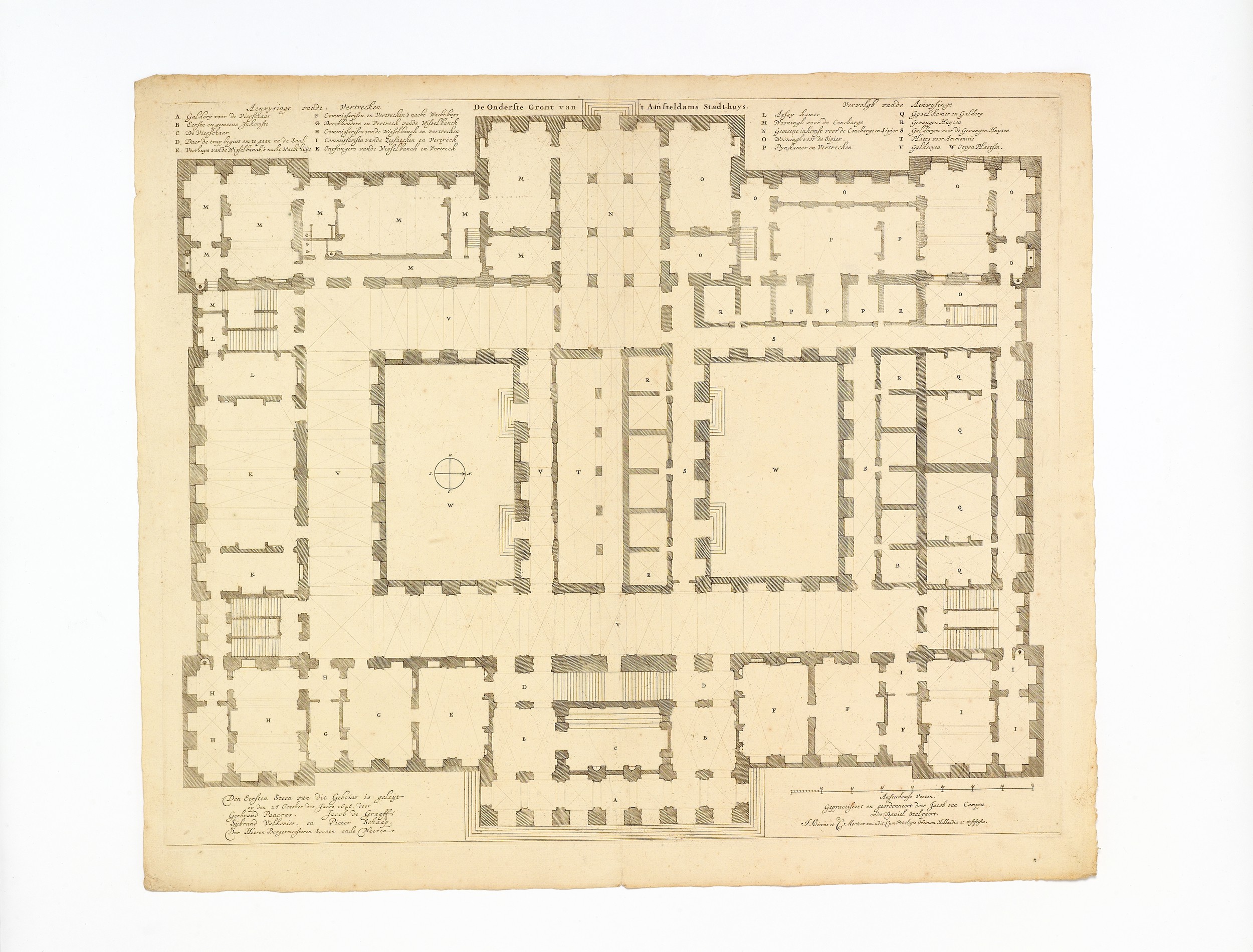
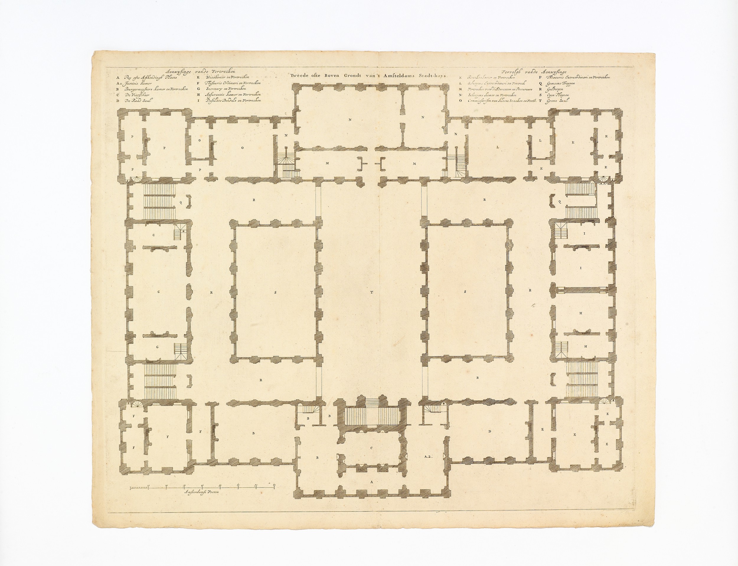
(iv) De Onderste Gront van ’t Amsteldams Stadt-huys with key (letters a–w) and (at bottom right) Gepractiseert en geordonneert door Jacob van Campen ende Daniel Stalpert. J. Covens et C. Mortier excudit. Cum Privilegio Ordinum Hollandiae et Westfrisiae
(v) Tweede ofte Boven Grondt van ’t Amsteldams Stadt-huys with key (letters a–t)
Joined to the suite is Daniel Stalpaert’s print of the south elevation of the Town Hall.1
paper watermark in all five sheets of a bow and arrow, incorporating initials is2
provenance Johannes Hermanus Henricus Leonhardt (1833–1904) — George Leonhardt (1866–1943) — George J.G. Leonhardt (1901–1981) — Mrs. G.E.A.M. Leonhardt-Pilz von Wernhof — Christie’s Amsterdam bv, ‘The Atlas of Amsterdam: drawings, prints, maps and books’, Amsterdam, 20 November 1989, lot 50
Old vertical centre folds, with a few minor repairs in margins; otherwise in very good state of preservation.
binding gathered in a modern portfolio.
Views and plans of the Town Hall on Dam Square in Amsterdam (now Royal Palace), designed by Jacob van Campen, and finished after his withdrawal from the project by the municipal architect, Daniel Stalpaert (1615–1676).
About 1650, while construction was still in progress, Stalpaert had published – in what ‘must have been a limited edition’3 – a set of five prints of the east, west, and south elevations, and plans of the ground and first floors, ‘record[ing] some parts of the project that were never executed’.4 Then in 1661, Van Campen’s draughtsman, Jacob Vennekool published a volume of plates consistently showing Van Campen’s original intentions for the building, prefaced by a dedicatory letter mentioning the architect’s wish that the Town Hall should be completed to his designs.5 The early stages of building and decoration were further documented by a series of engravings by Hubertus Quellinus, published 1665–1669; however, these too are unreliable, in that they include designs that were never executed.6

(reduced from 516 × 613 mm, platemark)


Very few impressions of Scherm’s prints have survived and it is not widely recognised that a set is comprised of five prints. Only the three views are described in Hollstein and we can trace only one other impression of his plan of the first floor.
Visscher edition
● Amsterdam, Stadsarchief, Collectie Atlas Dreesmann, 010094008173–75 (coloured impressions of our nos. i, ii, iii), 010056914973 (our no. iv with imprint ‘Nicolaus Visscher excudit. Cum privilegio Ordinum Hollandiae et Westfrisiae’)9 ● Amsterdam, Universiteits-Bibliotheek (nos. i, ii, iii)10 ● London, British Museum, Department of Prints & Drawings, Ee.8.25–26 (our nos. i–ii only)11 ● Nuremberg, Germanisches Nationalmuseum, Stadtpläne und Prospekte (our no. ii only)12 ● Vienna, Graphische Sammlung Albertina (our nos. i, ii, iii only)13
Covens & Mortier edition
● Amsterdam, Stadsarchief, Collectie tekeningen en prenten, 010097015548, 010097015527 (our nos. ii and iii) ● Veenhuizen, Nederlands Gevangenismuseum (our no. iii only?)14 ● Vienna, Österreichische Nationalbibliothek (our nos. i, ii, iii)15
Joined to the suite is Daniel Stalpaert’s print of the south elevation of the Town Hall.

references Georg Kaspar Nagler, Neues allgemeines Künstler-Lexicon (reprint Leipzig 1924), xvii, p.163; F.W.H. Hollstein, Dutch and Flemish etchings engravings woodcuts (Amsterdam 1980), xxiv, pp.178–179, nos. 19–21
1. Katharine Fremantle, The Baroque Town Hall of Amsterdam (Utrecht 1959), fig. 12.
2. Edward Heawood, ‘Papers used in England after 1600: ii. c. 1680–1750’ in The Library, second series, 11 (1931), p.473, observed in Henry Overton’s map of France (1707): ‘a precisely similar mark appears as countermark to the Strasburg arms in a work printed at Amsterdam in 1730, and the paper would seem to be French or Dutch, the is possibly standing for Jacques Salmon of Angoulême’; cf. E. Heawood, Watermarks mainly of the 17th and 18th centuries (Hilversum 1950), p.64 and pl.4 no. 32.
3. Wouter Kuyper, Dutch Classicist architecture (Delft 1980), p.213. Stalpaert’s privilege was for six prints, however for the north elevation he made do with a counterproof of the south. Very few impressions of Stalpaert’s prints are known; for reproductions, see Fremantle, op. cit., figs. 11–13, 191–192. ● Amsterdam, Stadsarchief, Collectie tekeningen en prenten, 010097016076-77, 01009003179, 010094003183 (both plans lacking) ● Amsterdam, Rijksmuseum (identified as Stalpaert’s own copy by Kuyper, op. cit., p.317 note 15) ● The Hague, Koninklijk Huisarchief, K.I. 6/16–21 (complete set).
4. Fremantle, op. cit., p.34.
5. Afbeelding van ’t Stadt Huys van Amsterdam, in dartigh coopere plaaten, geordineert door Jacob van Campen en geteeckent door Iacob Vennekool (Amsterdam 1661); see Fremantle, op. cit., p.202.
6. Van de voornaemste statuen ende ciraten, vant konstrijck Stadthuys van Amstelredam, tmeeste in marmer gemaeckt, door Artus Quellinus, beelthouwer der voorseyde stadt (Amsterdam 1665–1669); Fremantle, op. cit., p.201.
7. This patent for printing and publishing maps was granted to Visscher in 1682 and renewed 1697; he died in 1702. His widow carried on the business until 1720, when the company was liquidated (Cornelis Koeman, Atlantes Neerlandici, Amsterdam 1969, iii, p.153).
8. The partnership between Johannes Covens and Cornelis Mortier was notarized 20 November 1721; see I.H. Van Eeghen, De Amsterdamse Boekhandel 1680–1725 (Amsterdam 1965), iii, p.250. The prints appear in the firm’s stock catalogues of circa 1721 and 1738 as ‘La Maison de la ville d’Amsterdam, par Daniel Stalpaardt, en 5 feuilles’; see Marco van Egmond, Covens & Mortier: a map publishing house in Amsterdam, 1685–1866 (’t Goy-Houten 2009), pp.57, 68; Appendix viii p.140; Appendix ix p.228.
9. See image databank (http://beeldbank.amsterdam.nl).
10. Formerly in the collection of Albertus Theodorus Hartkamp (1848–1924), his sale by R.W.P. De Vries, ‘Catalogus van de Vondel Verzameling bijeengebracht door den Heer A.Th. Hartkamp’, Amsterdam, 11 November 1901, lot 832. Universiteit van Amsterdam Bibliotheek, Gids voor de bibliotheek der Universiteit van Amsterdam (Amsterdam 1919), iii (Vondelmuseum), p.24 no. 185.
11. See collection database (http://www.britishmuseum.org).
12. Alois Fauser, Repertorium älterer Topographie: Druckgraphik von 1486–1750 (Wiesbaden 1978), p.22 no. 412.
13. Located by Hollstein, op. cit., pp.178–179 nos. 19.i–21.i.
14. Reproduction on the Koninklijke Bibliotheek’s ‘Memory of the Netherlands’ database (http://www.geheugenvan-nederland.nl/?/en/items/NCRD01:092730051).
15. Located by Hollstein, op. cit., pp.178–179 nos. 19.ii–21.ii.